In and under Orvieto

Above and underground in Orvieto

This past week I have been very lucky to have a very dear friend visiting, and so I’ve been playing a bit more tourist than I normally do in Italy. We wanted to get out of Florence a bit, so we headed to nearby Orvieto, somewhere I have never been, and only about two hours on the regional (slow) train. Orvieto is located on a (very tall) hill, so we took the funicular from the bottom of the hill where the train dropped us off to the old town, and then headed straight for the main piazza del Duomo. We picked up tickets for our main interest first, and while we waited headed into the Duomo. Orvieto’s Duomo is pretty low-key overall, but the chapels are what are most noticeable and they are much more ornate than the rest of the empty-feeling church.

IMG_1970

The church is similar in feel to the Duomo in Siena, but as previously noted the chapels here are what are incredibly ornate. One chapel in particular was created for a piece of bloody cloth from when the wafer began to drip with the actual blood of Christ to convince a doubting priest. The cloth and host were taken to the pope, a miracle was declared and the chapel was built where the cloth is enshrined to this day. The majority of the frescos in that chapel were done by Luca Signorelli, and are said to have influenced Michelangelo’s frescos in the Sistine Chapel. The influence is obvious; Signorelli’s figures are incredibly muscular.

After viewing the church we headed from the beautiful city aboveground to under the ground, to the main attraction of Orvieto and what we were most excited to see: the Orvieto underground. During the time of the Etruscans thousands of man-made caves were dug out of the hillside and they are spread throughout the city. I tried to find an example of the map that you can see there, but was unsuccessful, but imagine a small Italian town city map: now draw thousands of red circles all over it and you’ll have an idea of how many caves there were and the reach of them. We took a guided tour in English, and were able to get some backstory on the caves and see them up close and personal.

The caves look pretty much like you would expect– they are caves after all– but what is perhaps most surprising is the temperature drop after you descend even just one level down into the caves. It is so much cooler there, and it is no surprise that the Etruscans used the caves for things such as olive oil making. Below you can see an ancient olive oil press. The straining mat is modern, but something similar would have been used to press the oil out of the olives and prevent pieces of the olives from joining the oil.

IMG_1979The caves were incredibly extensive; we felt we had seen so much, but in reality we only covered two tiny circles on the map of thousands. At one point our guide pointed out that while it seemed we had covered a lot of ground, it had all been vertical, and there certainly were a lot of stairs– this was not a tour for those who can’t do stairs– or the claustrophobic! The caves were quite spacious, but the tiny staircases and passages between them, not so much.

IMG_1981

Many of the rooms in the caves were studded with holes, as you can see in the photograph above. For a long time they believed that these holes had a different purpose, but now archeologists are pretty certain that they were used to raise pigeons, which are actually a pretty common food in Orvieto, one of the things the city is known for (the others being ceramics, Orvieto classico wine from Trebbiano grapes, and olive oil). The pigeons were self-maintaining, because they would fly out the window that was ever-present to eat, and also bring back food for their young. Unlike other animals such as rabbits, people did not have to put in as much effort to raise them.

After some time the caves reached their final hurrah when the people of Orvieto were forbidden from digging out any more caves due to the instability of the area; landslides, thanks to the instability caused by the caves were increasing and there was fear that the entire city might disappear. Now there are spikes driven through the hill to protect the city, but the caves are now an archeological and historical site as opposed to a functional one.

Orvieto, being a hill town, had beautiful views, and we spent the rest of the afternoon wandering and enjoying them before heading back to Florence on the train. Below you can see a convent (I believe) from the hillside where we entered the underground caves.

IMG_1975Orvieto was sacked by the Romans, but the city withstood their attacks for two years thanks to its prime hilltop position: easy to defend. There are walls around the city as well, and facing the train station you can climb atop for the best view of the valley below.

IMG_1984Sometimes living in Florence it’s easy to forget that Italy isn’t really a land of cities. I’m lucky enough to have a view of the hills from my balcony, but visiting a small hill town is a good reminder of what Italian life is really like for most people– in the past, and in the present.

IMG_1988

· · in Escapes, Europe, Off the Beaten Track, Out & About. ·

Keeping cool in Florence

60 years ago, someone made this snapshot in Florence.  I imagine it was hot then, and it is hot today.  If you can’t get to “il mare“, you can always cool off in the Arno river!


36623692_247313792743449_5047948940721258496_n

La spiaggia dei fiorentini fono agli anni 60-70. A sinistra la fabbrica dell’acqua smantellata negli anni 60.

The classic Italian car (la macchina)

From works of art and architecture, to products like olive oil and nutella, Italy’s strong cultural heritage means that it is full of things that are iconic and unequivocally Italian.

Although there are a few cars that fall under this category (Ferrari, Maserati, Alfa Romeo) my personal favorite is the Fiat.

377px-1973_Fiat_500L_500cc_Front

Not just any Fiat of course, but the Fiat 500. From the 1950′s to 1970′s, the cinquecento (five hundred) was produced and marketed as a cheap practical town car.

At about ten feet long, it makes the mini cooper look like a full-size sedan – seriously – I saw one here the other day and thought “WOW, that is huge,” which surprised me seeing as how it was the “cute little car” that I wanted in college. But I digress.

http://allafiorentina.com/florence/classic-italian-style-the-fiat-500/#.VEyVx77yQ21

Running circles around Florence

If you were a bird and could fly over the city of Florence, you would notice that there is a broad roadway that, in conjunction with the Arno river, encircles it.  This system of 4 to 6 lane highways are known as the Viali di Circonvallazione and it was constructed following the medieval walls that formerly encircled Florence.

Pretending you are a bird, this is what you see as you fly high over the city. Look for the yellow lines that surround the city with the Arno as the southern border.


Screen Shot 2018-06-15 at 2.45.07 PM


It might be easier to see it here:

Screen Shot 2018-06-15 at 2.44.20 PM

Starting in 1865, the medieval walls were demolished in an attempt to modernize and make Florence look more like other European capitals (especially Paris). Giuseppe Poggi designed an extensive urban plan for the city which was to create a Florence that was at same time more grand and more functional.

Many large tree-lined avenues, surrounding the historic center, were constructed in emulation of the grand boulevards of Paris.

When Poggi et al tore down the medieval walls, they fortunately spared almost all of the ancient gates to the city.  Large piazze were constructed near many of these gates, from which sprang wider and straighter roads.  Many residential palazzi were built to house the federal bourgeoisie that ran the newly united country.  I just happen to live on one of these leafy avenues now, and I send a silent but heartfelt thank you to Poggi up in heaven with Michelangelo and the rest of the artists I love.

A tramway was planned for Florence in 1873.  The trams made a circular route along Florence’s ring roads and provided transportation for the public. Line 19, for example, ran from Piazza dei Guidici near the Uffizi all the way along the Lungarni and ending at Piazza Vittorio Veneto on the east end of the Cascine.  This Google map will show you how the line ran along the Arno.

Screen Shot 2018-06-15 at 2.37.59 PM

Florence’s tram system was in operation until 1958.

Interestingly enough, Florence is in the midst of building a new electric tram system and all of us residents can’t wait until it is done and the construction sites are finally gone.


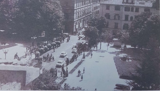
Piazza Beccaria, molti anni fa

Piazza Beccaria, many years ago.

35265840_226451901496305_9196519922795020288_n

Florence’s grand Piazza Beccaria was designed by the architect Giuseppe Poggi when Florence was made the Capital of the Kingdom of Italy.

It was originally called the Piazza alla Croce because one of the gates in the medieval walls that surrounded Florence, the Porta alla Croce, was located there and was left –more or less– intact.  This is the gate you see in the vintage photo above.

In 1876, the piazza was renamed in honor of Cesare Bonesana Marchese di Beccaria.   A number of concave palazzi were built to encircle the piazza. Just to the south stands the State Archives, where the Casa della Gioventu Italiana del Littorio previously stood.

In 2003 – 2004, a three-story underground parking garage was built under the square.  I walk over it every time I’m headed to the great shopping district to the east.  Two of the most beautiful modern (20th century) ville are located a stone’s throw away.

The Porta alla Croce was thankfully spared the destruction of the walls.

Poggi created a circular space in this piazza, with the ancient gate as a fulcrum, and a series of grand palazzi with concave facades. Moving south from the square, towards the Arno, the avenue had to bifurcate, leaving a plot of land in the center which is now occupied by the State Archives.

Screen Shot 2018-06-15 at 12.33.00 PM


At the bifurcation of the Giovine Italia and Amendola avenues, the building that houses the Archivio di Stato faces the place where until 1977 the Italian Youth House of the Littorio of Florence stood. Before that there were the so-called “Pratoni della Zecca”, an area that Poggi had planned to magnify the view from the hill of San Miniato towards Piazza Beccaria and vice versa.

Between 2003 and 2004, the square was affected by important works for the construction of an underground car park, for a total of 205 parking spaces organized on three floors, designed by the architects Paolo di Nardo and Fabio Rossetti , who in parallel also intervened in the partial rearrangement of the square’s furnishings [1] .

On the side and at the center of the circular avenues that cut it in half, the square presents three green areas (previously four) crossed by a pedestrian path that passes under the Porta alla Croce ; for several years the green space to the east, opposite to the one facing the center , has been deformed and reduced to the point of completely losing the elegant elliptical design; that just north of the portal was, instead, paved. The green flower beds are kept in lawn. On the west side, on 11 September 2009, the Municipality of Florence, in memory of Teresa Sarti Strada , planted a red maple . [2] . On the opposite side, however, the design of the flowerbeds has some trees (including a tall magnolia ) and bushes.